Nate • 13 May 2025
Deviation Analysis

Background
In the heart of a bustling city, two property owners entered into an easement agreement. The owner of an existing building granted easement rights to an adjacent property owner who was constructing a new hotel. The agreement contained a crucial clause: “any damage to the existing building caused by the hotel’s construction would be repaired at the hotel developer’s expense, restoring the building to its pre-loss condition.”
Objective
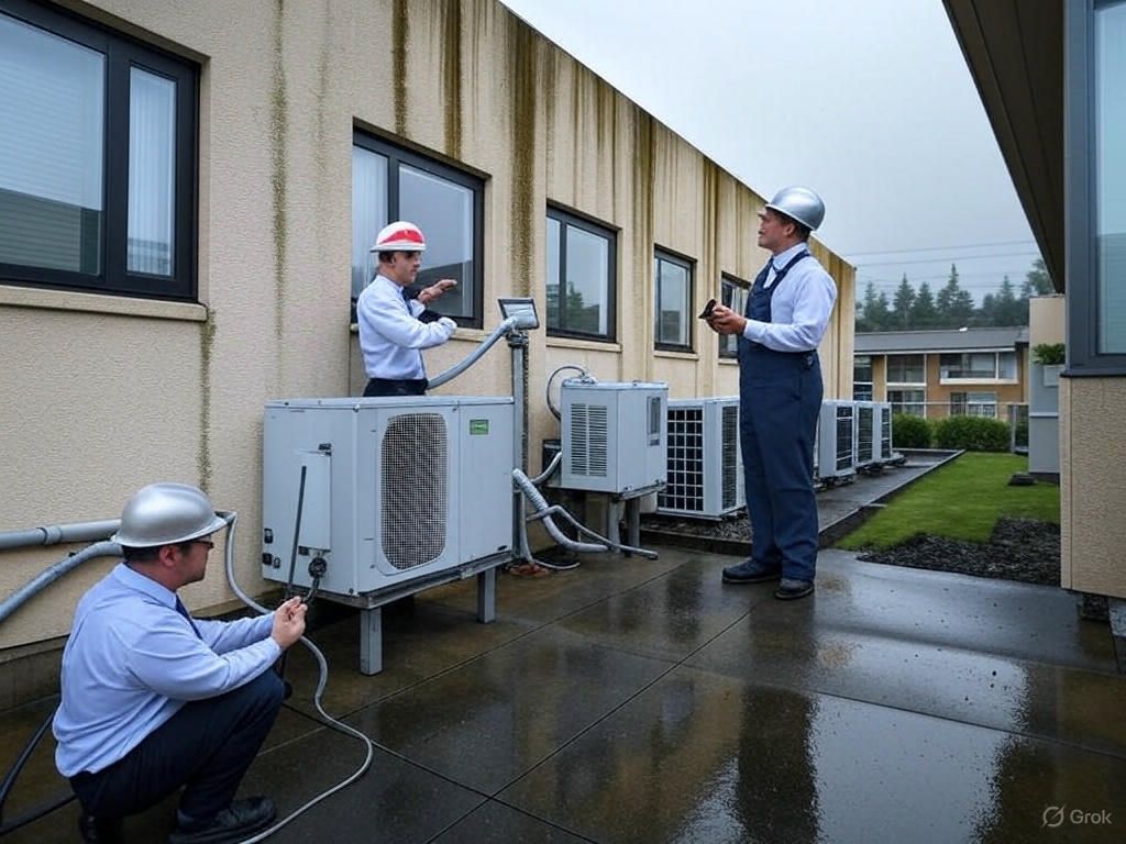
The objective was to conduct a thorough deviation analysis of the existing building post-property loss, using a combination of 3D capture digital twin technology, laser scanning, drone photography, crack gauges, and floor level manometer surveys.
Process
The process began with the creation of a 3D digital twin of the existing building, providing a precise virtual model for analysis. Laser scanning and drone photography were employed to capture detailed images and measurements of the building’s structure, identifying any deviations from the original state.
Crack gauges were strategically placed to monitor movement over time, while floor level manometer surveys measured any shifts in the building’s foundation. This multi-faceted approach allowed for a comprehensive assessment of the building’s condition before, during, and after the hotel’s construction.
Findings
The deviation analysis revealed areas where the construction activities had impacted the existing building. The digital twin and laser scans pinpointed structural shifts, while the crack gauges and manometer surveys confirmed the extent of the damage.
Resolution
Armed with concrete evidence from the advanced technological tools, the existing building’s owner was able to present a compelling case to the hotel developer, providing evidence of precisely where the building was damaged and what needed repair. As stipulated in the easement agreement, the hotel developer agreed to cover the costs of all necessary repairs.
This case study highlights the importance of clear easement agreements and the power of technology in upholding them. The use of 3D digital twins, laser scanning, drone photography, crack gauges, and manometer surveys provided an indisputable analysis of deviation, ensuring the integrity of the existing building and the accountability of the adjacent property owner.
Process Introduction
In the ever-evolving landscape of construction technology, precision and accuracy in building analysis have become paramount. This case study delves into the integration of 3D digital twins, laser scanning, floor contour mapping (Water level Manometer), and classical tape measure, and crack gauge measurements to perform deviation analysis on buildings, ensuring structural integrity and longevity.
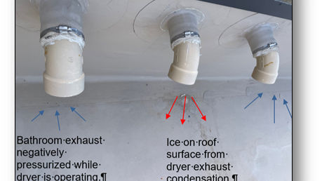
The water level Manometer works on the principle that water will equalize to the same level across a connected conduit, whether in the natural environment or a pipe/tube. The water level Manometer applies this principle to measure elevation differentials across horizontal surfaces. The diagram at the right displays how this is done. The stand with the reservoir is set at any location and defines the static base level. A reading is made on the scaled pipette on the stadia at the first survey point and then moved to the second location and read again. The elevation differential is the difference between the two readings.
The Challenge
Traditional methods of measuring deviations (assuming that empirical data was gathered prior to a deviation occurrence), such as crack gauges, provide limited data and lacked comprehensive coverage. The need for a holistic approach that offers detailed insights and predictive capabilities led to the exploration of advanced technological solutions.
The Solution
By harnessing the power of 3D digital twins (refer to the images to the right) and laser scanning, we created a multi-faceted approach to deviation analysis. The digital twin serves as a dynamic virtual model that mirrors the real-world structure, while laser scanning offers high-resolution data capturing the minutiae of the construction.
Digital Twin Technology
A digital twin provides a real-time, virtual representation of the building, allowing for continuous monitoring and analysis. It integrates data from various sources, including laser scans, to create an accurate model that evolves with the structure.
Laser Scanning
Laser scanning captures the physical reality of the building with precision, creating a point cloud that forms the basis of the digital twin. This method detects even the smallest deviations, which are critical for early intervention.
Crack Gauge Measurements
Classical crack gauge measurements complement the high-tech methods by providing a tangible reference point. These measurements validate the digital data and ensure that the analysis is grounded in physical reality.
The Results
The integration of these technologies resulted in a comprehensive deviation analysis system. The digital twin enabled predictive maintenance, and a digital replica of the building as a whole prior to any surrounding work being performed. The laser scanning provided a detailed assessment of the building’s condition. In addition to the crack gauge measurements, and floor level manometer survey, the above offered a reliable baseline for comparison after the adjacent construction project was started and completed.
Conclusion
The fusion of 3D digital twins, laser scanning, drone photographs, floor level manometer surveys, and crack gauge measurements represents a significant advancement in construction deviation analysis. This case study demonstrates the potential of these technologies to revolutionize the industry, ensuring safer and more resilient structures.